Archive for July, 2015

Jul 27 2015

Channel Islands Bald Eagles Thriving on Seabirds, Fish

fmgXiU7Pi1ileMwsuq_X0U_A2TFEeJWJNRZGtf-YQHWuWnUpGNco7r_5avCqxYzEsijvtikTjkG2lHBbSIH8AGX8w0HMsBm1xpBfxcMHTPKx6dwTRuOMVIA=s0-d-e1-ftA breeding male bald eagle is shown landing at the west end on Santa Catalina Island, Calif. – P. Sharpe

“Doing very well! Thanks for checking,” the bald eagles of California’s Channel Islands might well say to recent inquiries by researchers about their well-being.

The iconic birds were erased from the Channel Islands completely in the 1960s thanks to hunters, egg collectors, and the poisoning of their environment by the insecticide DDT.

But they have been reintroduced to the islands over the last three 35 years, and scientists writing in the latest issue of the journal The Condor: Ornithological Applications wanted to compare the eagles’ modern diet with that of the historical eagle population. Understanding how a habitat has changed between disappearance and reintroduction, they stress, is critical to gauging a species’ chance of thriving in an ancestral location.

Bald Eagle Lays Egg, Becomes Internet Sensation

Seth Newsome, of the University of New Mexico; Paul Collins, of the Santa Barbara Museum of Natural History; and Peter Sharpe, of the Institute for Wildlife Studies authored the study.

In 2010 and 2011, the trio examined the diets of the eagles and found the animals were indeed thriving, albeit from different dietary staples.

In the northern islands, the researchers found the eagles were eating much as they had before disappearing: they were feasting on seabirds.

Meanwhile, on the more southerly Santa Catalina Island, the eagles were, it turned out, eating primarily fish.

“Generally speaking,” explained Newsome in a release, “the northern islands are much more pristine, and a larger fraction of their coastlines includes areas where fishing is strongly regulated or banned.”

But Santa Catalina, Newsome noted, “has a larger human footprint, especially in the form of recreational fishing.”

The team thinks the eagles on Santa Catalina have figured out that the wisest thing to do when hungry is to look for the humans in the boats. “We believe that the differences in diversity of fish consumed by eagles in these two areas is actually a product of recreational fishing, and that eagles on Santa Catalina have learned to follow recreational fishing boats and scavenge discards thrown overboard,” said Newsome.

World’s Oldest Known Bird: Photos

While none of this thriving-on-seabirds news is terribly welcome if you’re a seabird, it nonetheless indicates something good. The researchers say the northern islands eagles’ abundant consumption of them shows that efforts to conserve seabirds in the area have been a boost to the whole ecosystem.

“Preserving diversity is wonderful,” Newsome said. “But you need to preserve diversity at all levels in the food chain. At present, such intact, fully-functioning food webs are relatively rare in the United States, but to see that happen in a place like the Channel Islands that is adjacent to an area with one of the highest human population densities in the U.S. (southern California) is exciting.”

These encouraging findings about the resurgent eagles come just days after news broke that the bald eagle population had expanded its reach to five of the eight Channel Islands, nesting on an island, San Clemente, that had not seen a nesting pair of bald eagles in more than half a century.


Read the original post: www.news.discovery.com

Jul 22 2015

Monterey Bay’s latest trick: turning turquoise

The water in the Monterey Bay, including off Marina State Beach, has been a turquoise color in the past few days because of the presence of coccolithophores, a single-celled phytoplankton that develops scales that reflect the sun. (Vern Fisher – Monterey Herald)

Monterey >> Our corner of the sea is turning a brighter shade of blue.

An odd and little-understood ocean phenomenon is taking place on Monterey Bay right now, and you may have noticed it: the waters are turning an almost tropical turquoise color. Derived from an abundance of a harmless microorganism, the colorful blooms are usually found in the open sea.

But Monterey Bay’s is the second bloom along the California coast in a month. It is due to the presence of coccolithophores, a single-celled phytoplankton that develops hubcap-shaped limestone scales that reflect the sun, turning the water pastel colored.

“The optics of the water when one gets coccolithophores blooms, it looks like this,” said Debora Iglesias-Rodriguez, a biological oceanographer with UC Santa Barbara, noting how odd it is to see a bloom along the shore. “This is really unusual.”

The organisms shed their scales in the water, with the phenomenon usually occurring in northern seas. When you have billions of them, they can impact huge stretches of the open sea, a visual that can be bizarre and stunning in its intensity.

“The blooms are so bright you have to wear sunglasses,” Iglesias-Rodriguez said.

In fact, coccolithophores are responsible for something most people are familiar with: the White Cliffs of Dover, along the English Channel. The striking white cliff faces were created from sediment filled with the organism’s discarded scales.

The first bloom showed up last month in the Santa Barbara Channel. Iglesias-Rodriguez said she is researching why it happened there, including whether the recent oil spill is a factor.

But late last week, it started showing up in Monterey Bay. Satellite data shows the waters from Point Pinos in the south to Natural Bridges State Beach in the north colored a vibrant hue.

Iglesias-Rodriguez is in touch with colleagues at the Monterey Bay Aquarium Research Institute in the hopes of comparing water samples. She said she can only find one unofficial record of the phenomenon occurring off Santa Barbara, dating to the 1990s.

“We are trying to figure out: Why now?” she said.

Coccolithophores seem to thrive when other phytoplankton cannot, particularly when marine phosphorous levels are low. They typically bloom in early summer.

“This would be the right time for them,” Iglesias-Rodriguez said.

This image from Saturday was created using data from NASA’s AQUA satellite, with help from biological oceanographer John Ryan at the Monterey Bay Aquarium Research Institute. The turquoise water is created by the presence of a microorganism. (Courtesy MBARI)


Read the original post: www.montereyherald.com

Jul 17 2015

Warming of Oceans Due to Climate Change is Unstoppable, Say US Scientists

— Posted with permission of SEAFOODNEWS.COM. Please do not republish without their permission. —

Copyright © 2015 Seafoodnews.com

Seafood NewsYW5gmus_7UB6BswTlrlQl16gedNCZbAnq9GsLMJbi9TQXMtRr-31UN9JVN0X8WoHG1cxbbw32MNYluOaDq895pCQ07YA24YTAlUyNOw=s0-d-e1-ft

The warming of the oceans due to climate change is now unstoppable after record temperatures last year, bringing additional sea-level rise, and raising the risks of severe storms, US government climate scientists said on Thursday.

The annual State of the Climate in 2014 report, based on research from 413 scientists from 58 countries, found record warming on the surface and upper levels of the oceans, especially in the North Pacific, in line with earlier findings of 2014 as the hottest year on record.

Global sea-level also reached a record high, with the expansion of those warming waters, keeping pace with the 3.2 ± 0.4 mm per year trend in sea level growth over the past two decades, the report said.

Scientists said the consequences of those warmer ocean temperatures would be felt for centuries to come – even if there were immediate efforts to cut the carbon emissions fuelling changes in the oceans.

“I think of it more like a fly wheel or a freight train. It takes a big push to get it going but it is moving now and will contiue to move long after we continue to pushing it,” Greg Johnson, an oceanographer at Noaa’s Pacific Marine Environmental Laboratory, told a conference call with reporters.

“Even if we were to freeze greenhouse gases at current levels, the sea would actually continue to warm for centuries and millennia, and as they continue to warm and expand the sea levels will continue to rise,” Johnson said.

On the west coast of the US, freakishly warm temperatures in the Pacific – 4 or 5F above normal – were already producing warmer winters, as well as worsening drought conditions by melting the snowpack, he said.

The extra heat in the oceans was also contributing to more intense storms, Tom Karl, director of Noaa’s National Centers for Environmental Information, said.

The report underlined 2014 as a banner year for the climate, setting record or near record levels for temperature extremes, and loss of glaciers and sea ice, and reinforcing decades-old pattern to changes to the climate system.

Four independent data sets confirmed 2014 as the hottest year on record, with much of that heat driven by the warming of the oceans.

Globally 90% of the excess heat caused by the rise in greenhouse gas emissions is absorbed by the oceans.

More than 20 countries in Europe set new heat records, with Africa, Asia and Australia also experiencing near-record heat. The east coast of North America was the only region to experience cooler than average conditions.

Alaska experienced temperatures 18F warmer than average. Spring break-up came to the Arctic 20-30 days earlier than the 20th century average.

“The prognosis is to expect a continuation of what we have seen,” Karl said.


Subscribe to Seafoodnews.com

Jul 9 2015

Whales’ feeding frenzy at Farallones a feast for the eyes

whalePhoto: Peter Winch/Oceanic Society

A humpback whale in full breach last Sunday near the Southeast Farallon Island — researchers stationed at the island counted 93 humpback whales, 21 blue whales and one fin whale in a single hour


In one magic hour Sunday, researchers stationed at the South Farallon Islands counted 93 humpback whales, 21 blue whales and one fin whale, according to Mary Jane Schramm of the Greater Farallones National Marine Sanctuary.

There hasn’t been anything like this verified in modern times.

In addition, onlookers at Land’s End saw eight to 10 humpbacks just a mile offshore — pectoral fin slapping, lob tailing and both singular and serial breaching, reported Nan Sincero of the Oceanic Society and field scout Paul Judge.

At the same time, on a whale-watching trip with the Oceanic Society on the Salty Lady out of San Francisco, Capt. Roger Thomas said he sighted 25 humpbacks and three blue whales, most within range of Southeast Farallon Island.

“It’s like an eating contest out there,” Schramm said.

A vast amount of krill has brought in the blue whales. Large schools of anchovies and mackerel have attracted the humpbacks.

“One blue can consume up to four tons of krill per day when in maximum feeding mode,” Schramm said. “That’s right now, apparently, and right here.”

Blue whales are the biggest air-breathing mammals on Earth. Often double the size of a bus, when they surge to the surface to feed, you might see them emerge with krill-loaded seawater gushing from their giant mouths.

Several factors explain their arrival. Last month, a strong wind out of the northwest pushed across the sea toward the Bay Area. Along with the wind came cold, deep, nutrient-rich water from the edges of the continental shelf, where it surged upward to the surface waters of the Gulf of the Farallones Sanctuary.

When sunlight penetrated that nutrient-rich water, it launched the marine food chain. The most obvious result from this major upwelling event is the abundance of krill. All the critters offshore, from nesting murres and puffins at the Farallones to salmon — and to blue whales — have been feasting.

The result is that there may be no better time to see a blue whale than now. Some avid wildlife watchers can go a lifetime without sighting a blue whale, and yet to say we would expect it on a trip this weekend is mind-boggling.

Yet big blue is not alone. Humpback whales, often about 50 feet and 40 tons — known for their spectacular jumps and pirouettes — also have arrived in high numbers.

With your boat in neutral, humpbacks often will approach as if to show off.

I’ve had them jump right alongside, splashing everyone on board. Another time, I watched a dozen humpbacks jump in half-spin pirouettes around us for an hour. In another encounter, a dozen humpbacks swam in a coordinated circle just ahead of us, blowing bubbles to create an underwater curtain and keep their feed encircled while they took turns diving and then lunge-feeding through the center of the circle.

Last year, in Monterey Bay, I paddled out 10 miles and had a humpback surface so close that it hit me with the spray from its blowhole.

The largest number of sightings in the past week have been by land-based researchers called “Point Blue.” This is the latest incarnation of the Point Reyes Bird Observatory, which contracts with the U.S. Fish and Wildlife Service to maintain a presence on Southeast Farallon Island. They are deeply involved in seabird research, but their work includes one-hour daily snapshots, a part of larger efforts to prevent whale deaths from collisions with large vessels.

The second-highest number of sightings have been on whale-watching boats, such as the Salty Lady with the Oceanic Society. Thomas said captains have pinpointed the location of the blue whales, and in the process, many humpbacks have been sighted as well, plus a huge array of shorebirds attracted to the area by feed.

On land, the best sites to see whales at the mouth of the bay have been Lands End and lookouts along the coastal trail on the San Francisco Headlands, and at Point Bonita Lighthouse and cliff-top lookouts along the west end of Conzelman Road at the Marin Headlands.

“The humpbacks at the entrance to the bay have been hanging out for weeks,” Sincero said. “They are in heaven with all the food out there.

“There’s a young humpback I saw that loves to come up to the surface and curl its back, almost like Nessie (the Loch Ness Monster), and has been breaching quite a bit, too.”

It seems every week there is news of another landmark event along the coast. It’s becoming a golden era for the Greater Farallones Sanctuary.

Info: Farallon Islands Whale Watching, Oceanic Society, reserve at (415) 256-9604, whale hotline at (415) 258- 8220; www.oceanicsociety.org.

Tom Stienstra’s Outdoor Report can be heard at 7:35 a.m., 9:35 a.m. and 12:35 p.m. Saturdays on KCBS (740 and 106.9). E-mail: tstienstra@sfchronicle.com Twitter: @StienstraTom

Purple blobs explained

At low tide this week on the Berkeley shoreline near Ashby Avenue, giant purple blobs covered half of the exposed beach, field scout Stephanie Manning reported.

They are sea slugs — formally called sea hares — from Baja, said Mary Jane Schramm of the Greater Farallones National Marine Sanctuary.

“The likelihood is that the die-off is the end stage of a mass-mating event,” Schramm said. “These seemingly ill-favored critters are quite the party animals.”

She said such seasonal mass events occur naturally all along the sea slug’s range to southern Mexico, often in remote, pristine areas.

The sea slugs have been washing up at Berkeley for about three weeks. Many believe their arrival in Bay Area waters, like that of the rookery of great white sharks two weeks ago in Monterey Bay near Santa Cruz, is a harbinger of the formation of an El Niño and a broad offshore warming of Pacific currents.


Read the original post: www.sfgate.com

Jul 9 2015

El Nino Impacts Could be Among Strongest Ever, Stretch Into 2016 After Series of Cyclones

— Posted with permission of SEAFOODNEWS.COM. Please do not republish without their permission. —

Copyright © 2015 Seafoodnews.com

Seafood News

species

The El Nino climate pattern building in the Pacific is on track to be one of the strongest on record, with recent cyclones likely to intensify the event, the Bureau of Meteorology said.

Sea-surface temperatures in the central equatorial Pacific in June recorded the second largest anomalies on record for the month, behind only the June 1997 reading during the super 1997-98 El Nino event, the bureau said in its latest update.

Weekly sea-surface temperatures were also more than 1 degree above average for each of the regions monitored, their warmest sustained values since the 1997-98 event.

A string of tropical cyclones, including the rare July southern hemisphere storm, Cyclone Raquel, mean the El Nino will likely strengthen in coming weeks as “a strong reversal of trade winds” near the equator takes place.

“This is likely to increase temperatures below the surface of the tropical Pacific Ocean, which may in turn raise sea-surface temperatures further in the coming months,” the bureau said.

Unlike the last few El Ninos, the eastern Pacific is particularly warm, much like the “canonical” events of 1982-83 and 1997-98, Lynette Bettio, a senior climatologist with the bureau said. Model projections also have the event lasting well into next autumn.

The Southern Oscillation Index, which measures the pressure difference between Darwin and Tahiti, had also dropped sharply in recent weeks, one gauge watched closely by farmers worried about the rainfall outlook, she said.

El Ninos are characterised by central and eastern parts of the Pacific warming relative to those in the west. One result is that the normally easterly trade winds slow or reverse, with rainfall patterns tending to shift eastwards away from eastern Australia and south-east Asia.

Cool patch coming

While global temperatures tend to be boosted by El Ninos, the pattern does not mean all regions are warmer than usual for the event’s duration.

Australia, for instance, is about to enter a relatively cool patch mostly as a series of powerful cold fronts from the south penetrate unusually far to the north.

The first of them should move across south-eastern Australia on Friday and Saturday, and “is going to be the coldest front of the year”, Tristan Meyers, a meteorologist at Weatherzone, said.  (See below for Sunday’s synoptic chart.)

Temperatures will be noticeably cooler in Melbourne, with the maximum dropping from 15 degrees on Thursday to 11-13 from Saturday to Tuesday. In Sydney, relatively mild maximums of 19 degrees on Friday and Saturday will retreat to 15 degrees by Sunday.

“We’re going to see some frost up in south-east Queensland,” Mr Meyers said.

Towns such as Stanthorpe will likely have a top of just 8 degrees on Sunday and Monday, with overnight lows of minus-2 to zero, according to the bureau.

While the front as a while won’t be bringing a lot of rain, the ski resorts should receive another 10 centimetres or so of snow to boost their thin natural cover, Mr Meyer said, adding that more fronts won’t be far behind.


Subscribe to seafoodnews.com

Jul 6 2015

Strong Westerlies Push El Nino Toward Extreme Event

For the past two weeks, winds have been blowing in an anomalous west-to-east pattern across the Western Pacific. It’s the third such pattern since El Nino conditions began to become more prevalent during March of this year. And forecast model response to the most recent westerly wind burst is an overall shift toward predicting a record event. Models are starting to settle on at least a strong El Nino come fall (1.5 degree Celsius anomaly or greater for Nino 3.4) with many ensembles predicting something even more intense than the super El Nino of 1998.

This third, El Nino heightening, westerly wind burst (WWB) coincided with a strong, wet variation of the Madden Julian Oscillation pumping up thunderstorm activity throughout the region. Last week, a consistent 20-35 mph westerly wind pattern had become very well established. Over the past four days, multiple cyclones became embedded within the pattern, which now stretches over 3,000 miles in length, pushing locally stronger winds and reinforcing the already significant wind field.

By today four cyclonic systems, including Typhoon Chan-Hom, had further heightened westerly wind intensity:

image

(The current strong westerly wind burst is looking more and more like the extreme event of early March of this year. It’s the third such event — one that is increasing the likelihood that the 2015 El Nino will be one more for the record books. Image source: Earth Nullschool.)

It’s a pattern that in today’s map looks very similar to the record event which occurred this Spring. And it’s the third significant WWB to initiate since March of this year.

WWBs push warm surface water in the Western Pacific downward and across the ocean (read more about how WWBs affect El Nino severity here). These warm water pulses traverse thousands of miles, finally resurfacing in the Eastern Pacific off South America. The resultant warming of surface waters there and through the mid ocean region tends to set in place ocean temperature and atmospheric patterns that reinforce El Nino — driving more westerly winds and still more warm water displacement eastward.

Three westerly wind bursts firing off since March of 2015 have pushed increasingly strong El Nino conditions. A warming of the Equatorial Pacific that, in combination with a massive and rapidly growing greenhouse gas overburden from human fossil fuel burning, is forcing  global temperature readings to hit new record high after new record high.

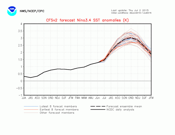
Nino 3.4 CSV2

(CFSv2 Model runs are pointing toward a very powerful anomaly come Fall. Image source: Climate Prediction Center.)

This third strong westerly wind burst appears to have again pushed model forecasts into very extreme ranges for Fall of this year. NOAA’s CFSv2 ensembles now predicts a peak sea surface temperature anomaly in the range of 2.5 degrees Celsius above average to 3.1 degrees Celsius above average. An El Nino of this strength would be significantly stronger than the monster event of 1998. One that would occur in a global context that includes an approximate 45 parts per million CO2e worth of heat trapping gas accumulation since that time. One that is now in the range of 1 C warming above 1880s averages (or 1/4th the difference between now and the last ice age, but on the side of hot).

Since we are now well past the spring predictability barrier, these new model runs have a higher potential accuracy. That said, we are still four months out and a number of additional factors would have to come into play to lock in such a powerful event. However, the trend is still for a strong to extraordinarily powerful El Nino. And since such an event is occurring in a record warm atmosphere and ocean environment (due to human-caused climate change), the continued potential for related additional anomalous weather events (drought, flood, wildfires, extreme tropical cyclones in the Pacific, etc) is also high enough to remain a serious concern.


Read the original post: https://robertscribbler.wordpress.com/