Archive for the Breaking News Category

Jul 17 2015

Warming of Oceans Due to Climate Change is Unstoppable, Say US Scientists

— Posted with permission of SEAFOODNEWS.COM. Please do not republish without their permission. —

Copyright © 2015 Seafoodnews.com

Seafood NewsYW5gmus_7UB6BswTlrlQl16gedNCZbAnq9GsLMJbi9TQXMtRr-31UN9JVN0X8WoHG1cxbbw32MNYluOaDq895pCQ07YA24YTAlUyNOw=s0-d-e1-ft

The warming of the oceans due to climate change is now unstoppable after record temperatures last year, bringing additional sea-level rise, and raising the risks of severe storms, US government climate scientists said on Thursday.

The annual State of the Climate in 2014 report, based on research from 413 scientists from 58 countries, found record warming on the surface and upper levels of the oceans, especially in the North Pacific, in line with earlier findings of 2014 as the hottest year on record.

Global sea-level also reached a record high, with the expansion of those warming waters, keeping pace with the 3.2 ± 0.4 mm per year trend in sea level growth over the past two decades, the report said.

Scientists said the consequences of those warmer ocean temperatures would be felt for centuries to come – even if there were immediate efforts to cut the carbon emissions fuelling changes in the oceans.

“I think of it more like a fly wheel or a freight train. It takes a big push to get it going but it is moving now and will contiue to move long after we continue to pushing it,” Greg Johnson, an oceanographer at Noaa’s Pacific Marine Environmental Laboratory, told a conference call with reporters.

“Even if we were to freeze greenhouse gases at current levels, the sea would actually continue to warm for centuries and millennia, and as they continue to warm and expand the sea levels will continue to rise,” Johnson said.

On the west coast of the US, freakishly warm temperatures in the Pacific – 4 or 5F above normal – were already producing warmer winters, as well as worsening drought conditions by melting the snowpack, he said.

The extra heat in the oceans was also contributing to more intense storms, Tom Karl, director of Noaa’s National Centers for Environmental Information, said.

The report underlined 2014 as a banner year for the climate, setting record or near record levels for temperature extremes, and loss of glaciers and sea ice, and reinforcing decades-old pattern to changes to the climate system.

Four independent data sets confirmed 2014 as the hottest year on record, with much of that heat driven by the warming of the oceans.

Globally 90% of the excess heat caused by the rise in greenhouse gas emissions is absorbed by the oceans.

More than 20 countries in Europe set new heat records, with Africa, Asia and Australia also experiencing near-record heat. The east coast of North America was the only region to experience cooler than average conditions.

Alaska experienced temperatures 18F warmer than average. Spring break-up came to the Arctic 20-30 days earlier than the 20th century average.

“The prognosis is to expect a continuation of what we have seen,” Karl said.


Subscribe to Seafoodnews.com

Jul 9 2015

Whales’ feeding frenzy at Farallones a feast for the eyes

whalePhoto: Peter Winch/Oceanic Society

A humpback whale in full breach last Sunday near the Southeast Farallon Island — researchers stationed at the island counted 93 humpback whales, 21 blue whales and one fin whale in a single hour


In one magic hour Sunday, researchers stationed at the South Farallon Islands counted 93 humpback whales, 21 blue whales and one fin whale, according to Mary Jane Schramm of the Greater Farallones National Marine Sanctuary.

There hasn’t been anything like this verified in modern times.

In addition, onlookers at Land’s End saw eight to 10 humpbacks just a mile offshore — pectoral fin slapping, lob tailing and both singular and serial breaching, reported Nan Sincero of the Oceanic Society and field scout Paul Judge.

At the same time, on a whale-watching trip with the Oceanic Society on the Salty Lady out of San Francisco, Capt. Roger Thomas said he sighted 25 humpbacks and three blue whales, most within range of Southeast Farallon Island.

“It’s like an eating contest out there,” Schramm said.

A vast amount of krill has brought in the blue whales. Large schools of anchovies and mackerel have attracted the humpbacks.

“One blue can consume up to four tons of krill per day when in maximum feeding mode,” Schramm said. “That’s right now, apparently, and right here.”

Blue whales are the biggest air-breathing mammals on Earth. Often double the size of a bus, when they surge to the surface to feed, you might see them emerge with krill-loaded seawater gushing from their giant mouths.

Several factors explain their arrival. Last month, a strong wind out of the northwest pushed across the sea toward the Bay Area. Along with the wind came cold, deep, nutrient-rich water from the edges of the continental shelf, where it surged upward to the surface waters of the Gulf of the Farallones Sanctuary.

When sunlight penetrated that nutrient-rich water, it launched the marine food chain. The most obvious result from this major upwelling event is the abundance of krill. All the critters offshore, from nesting murres and puffins at the Farallones to salmon — and to blue whales — have been feasting.

The result is that there may be no better time to see a blue whale than now. Some avid wildlife watchers can go a lifetime without sighting a blue whale, and yet to say we would expect it on a trip this weekend is mind-boggling.

Yet big blue is not alone. Humpback whales, often about 50 feet and 40 tons — known for their spectacular jumps and pirouettes — also have arrived in high numbers.

With your boat in neutral, humpbacks often will approach as if to show off.

I’ve had them jump right alongside, splashing everyone on board. Another time, I watched a dozen humpbacks jump in half-spin pirouettes around us for an hour. In another encounter, a dozen humpbacks swam in a coordinated circle just ahead of us, blowing bubbles to create an underwater curtain and keep their feed encircled while they took turns diving and then lunge-feeding through the center of the circle.

Last year, in Monterey Bay, I paddled out 10 miles and had a humpback surface so close that it hit me with the spray from its blowhole.

The largest number of sightings in the past week have been by land-based researchers called “Point Blue.” This is the latest incarnation of the Point Reyes Bird Observatory, which contracts with the U.S. Fish and Wildlife Service to maintain a presence on Southeast Farallon Island. They are deeply involved in seabird research, but their work includes one-hour daily snapshots, a part of larger efforts to prevent whale deaths from collisions with large vessels.

The second-highest number of sightings have been on whale-watching boats, such as the Salty Lady with the Oceanic Society. Thomas said captains have pinpointed the location of the blue whales, and in the process, many humpbacks have been sighted as well, plus a huge array of shorebirds attracted to the area by feed.

On land, the best sites to see whales at the mouth of the bay have been Lands End and lookouts along the coastal trail on the San Francisco Headlands, and at Point Bonita Lighthouse and cliff-top lookouts along the west end of Conzelman Road at the Marin Headlands.

“The humpbacks at the entrance to the bay have been hanging out for weeks,” Sincero said. “They are in heaven with all the food out there.

“There’s a young humpback I saw that loves to come up to the surface and curl its back, almost like Nessie (the Loch Ness Monster), and has been breaching quite a bit, too.”

It seems every week there is news of another landmark event along the coast. It’s becoming a golden era for the Greater Farallones Sanctuary.

Info: Farallon Islands Whale Watching, Oceanic Society, reserve at (415) 256-9604, whale hotline at (415) 258- 8220; www.oceanicsociety.org.

Tom Stienstra’s Outdoor Report can be heard at 7:35 a.m., 9:35 a.m. and 12:35 p.m. Saturdays on KCBS (740 and 106.9). E-mail: tstienstra@sfchronicle.com Twitter: @StienstraTom

Purple blobs explained

At low tide this week on the Berkeley shoreline near Ashby Avenue, giant purple blobs covered half of the exposed beach, field scout Stephanie Manning reported.

They are sea slugs — formally called sea hares — from Baja, said Mary Jane Schramm of the Greater Farallones National Marine Sanctuary.

“The likelihood is that the die-off is the end stage of a mass-mating event,” Schramm said. “These seemingly ill-favored critters are quite the party animals.”

She said such seasonal mass events occur naturally all along the sea slug’s range to southern Mexico, often in remote, pristine areas.

The sea slugs have been washing up at Berkeley for about three weeks. Many believe their arrival in Bay Area waters, like that of the rookery of great white sharks two weeks ago in Monterey Bay near Santa Cruz, is a harbinger of the formation of an El Niño and a broad offshore warming of Pacific currents.


Read the original post: www.sfgate.com

Jul 9 2015

El Nino Impacts Could be Among Strongest Ever, Stretch Into 2016 After Series of Cyclones

— Posted with permission of SEAFOODNEWS.COM. Please do not republish without their permission. —

Copyright © 2015 Seafoodnews.com

Seafood News

species

The El Nino climate pattern building in the Pacific is on track to be one of the strongest on record, with recent cyclones likely to intensify the event, the Bureau of Meteorology said.

Sea-surface temperatures in the central equatorial Pacific in June recorded the second largest anomalies on record for the month, behind only the June 1997 reading during the super 1997-98 El Nino event, the bureau said in its latest update.

Weekly sea-surface temperatures were also more than 1 degree above average for each of the regions monitored, their warmest sustained values since the 1997-98 event.

A string of tropical cyclones, including the rare July southern hemisphere storm, Cyclone Raquel, mean the El Nino will likely strengthen in coming weeks as “a strong reversal of trade winds” near the equator takes place.

“This is likely to increase temperatures below the surface of the tropical Pacific Ocean, which may in turn raise sea-surface temperatures further in the coming months,” the bureau said.

Unlike the last few El Ninos, the eastern Pacific is particularly warm, much like the “canonical” events of 1982-83 and 1997-98, Lynette Bettio, a senior climatologist with the bureau said. Model projections also have the event lasting well into next autumn.

The Southern Oscillation Index, which measures the pressure difference between Darwin and Tahiti, had also dropped sharply in recent weeks, one gauge watched closely by farmers worried about the rainfall outlook, she said.

El Ninos are characterised by central and eastern parts of the Pacific warming relative to those in the west. One result is that the normally easterly trade winds slow or reverse, with rainfall patterns tending to shift eastwards away from eastern Australia and south-east Asia.

Cool patch coming

While global temperatures tend to be boosted by El Ninos, the pattern does not mean all regions are warmer than usual for the event’s duration.

Australia, for instance, is about to enter a relatively cool patch mostly as a series of powerful cold fronts from the south penetrate unusually far to the north.

The first of them should move across south-eastern Australia on Friday and Saturday, and “is going to be the coldest front of the year”, Tristan Meyers, a meteorologist at Weatherzone, said.  (See below for Sunday’s synoptic chart.)

Temperatures will be noticeably cooler in Melbourne, with the maximum dropping from 15 degrees on Thursday to 11-13 from Saturday to Tuesday. In Sydney, relatively mild maximums of 19 degrees on Friday and Saturday will retreat to 15 degrees by Sunday.

“We’re going to see some frost up in south-east Queensland,” Mr Meyers said.

Towns such as Stanthorpe will likely have a top of just 8 degrees on Sunday and Monday, with overnight lows of minus-2 to zero, according to the bureau.

While the front as a while won’t be bringing a lot of rain, the ski resorts should receive another 10 centimetres or so of snow to boost their thin natural cover, Mr Meyer said, adding that more fronts won’t be far behind.


Subscribe to seafoodnews.com

Jul 6 2015

Strong Westerlies Push El Nino Toward Extreme Event

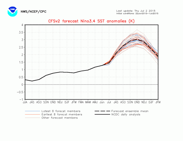
For the past two weeks, winds have been blowing in an anomalous west-to-east pattern across the Western Pacific. It’s the third such pattern since El Nino conditions began to become more prevalent during March of this year. And forecast model response to the most recent westerly wind burst is an overall shift toward predicting a record event. Models are starting to settle on at least a strong El Nino come fall (1.5 degree Celsius anomaly or greater for Nino 3.4) with many ensembles predicting something even more intense than the super El Nino of 1998.

This third, El Nino heightening, westerly wind burst (WWB) coincided with a strong, wet variation of the Madden Julian Oscillation pumping up thunderstorm activity throughout the region. Last week, a consistent 20-35 mph westerly wind pattern had become very well established. Over the past four days, multiple cyclones became embedded within the pattern, which now stretches over 3,000 miles in length, pushing locally stronger winds and reinforcing the already significant wind field.

By today four cyclonic systems, including Typhoon Chan-Hom, had further heightened westerly wind intensity:

image

(The current strong westerly wind burst is looking more and more like the extreme event of early March of this year. It’s the third such event — one that is increasing the likelihood that the 2015 El Nino will be one more for the record books. Image source: Earth Nullschool.)

It’s a pattern that in today’s map looks very similar to the record event which occurred this Spring. And it’s the third significant WWB to initiate since March of this year.

WWBs push warm surface water in the Western Pacific downward and across the ocean (read more about how WWBs affect El Nino severity here). These warm water pulses traverse thousands of miles, finally resurfacing in the Eastern Pacific off South America. The resultant warming of surface waters there and through the mid ocean region tends to set in place ocean temperature and atmospheric patterns that reinforce El Nino — driving more westerly winds and still more warm water displacement eastward.

Three westerly wind bursts firing off since March of 2015 have pushed increasingly strong El Nino conditions. A warming of the Equatorial Pacific that, in combination with a massive and rapidly growing greenhouse gas overburden from human fossil fuel burning, is forcing  global temperature readings to hit new record high after new record high.

Nino 3.4 CSV2

(CFSv2 Model runs are pointing toward a very powerful anomaly come Fall. Image source: Climate Prediction Center.)

This third strong westerly wind burst appears to have again pushed model forecasts into very extreme ranges for Fall of this year. NOAA’s CFSv2 ensembles now predicts a peak sea surface temperature anomaly in the range of 2.5 degrees Celsius above average to 3.1 degrees Celsius above average. An El Nino of this strength would be significantly stronger than the monster event of 1998. One that would occur in a global context that includes an approximate 45 parts per million CO2e worth of heat trapping gas accumulation since that time. One that is now in the range of 1 C warming above 1880s averages (or 1/4th the difference between now and the last ice age, but on the side of hot).

Since we are now well past the spring predictability barrier, these new model runs have a higher potential accuracy. That said, we are still four months out and a number of additional factors would have to come into play to lock in such a powerful event. However, the trend is still for a strong to extraordinarily powerful El Nino. And since such an event is occurring in a record warm atmosphere and ocean environment (due to human-caused climate change), the continued potential for related additional anomalous weather events (drought, flood, wildfires, extreme tropical cyclones in the Pacific, etc) is also high enough to remain a serious concern.


Read the original post: https://robertscribbler.wordpress.com/

Jun 30 2015

Fishing Grounds Reopen After Refugio Oil Spill

To the surprise of pretty much everybody paying attention to the 138-square-mile closure of all fishing grounds in and around the May 19 Refugio Oil Spill site, the California Department of Fish and Wildlife reopened the closed region on Monday afternoon.

As of late last week, there was no indication that fishermen would be permitted access to the area any time soon. “Turnaround was incredibly quick and everybody was stoked that all those fish came in clean,” said commercial fisherman Michael Harrington, referring to the range of invertebrates and finfish that were collected and tested for contamination.

Fish and Wildlife spokesperson Alexia Retallack said that the Office of Environmental Health Hazard Assessment “worked with the testing labs to expedite the process.” The emergency closure covered an area from Coal Oil Point to Hollister ranch, six miles out to sea.

Commercial and recreational fishing is still restricted within the Naples and Campus Point marine conservation areas, both of which were established in 2012. Also, the annual mussel quarantine — to protect the public against paralytic shellfish poisoning — is currently in effect and typically runs until the end of October.


Read the original article: http://www.independent.com

Jun 29 2015

A Tale of Two Whales: Seven-Year Study Indicates Steady and Upward Trends for Blue and Fin Whales in Southern California

Scripps-led study used acoustic data to provide the first detailed view of calling blue and fin whale distribution in the waters off Southern California

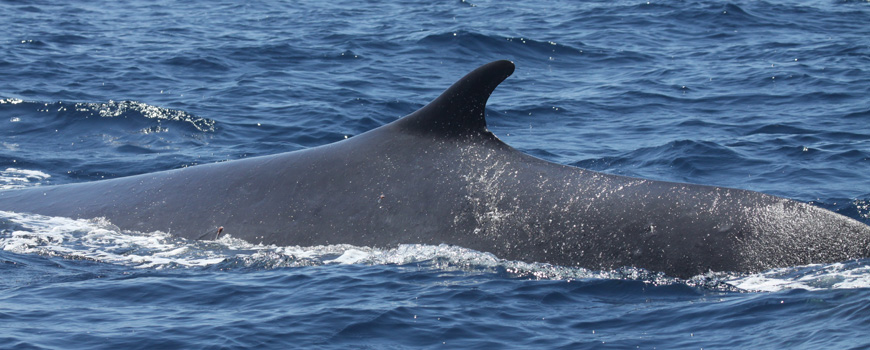
A fin whale.

A fin whale off Southern California. Photo taken under NMFS Permit No. 727-1915.


A new study led by researchers at Scripps Institution of Oceanography at UC San Diego indicates a steady population trend for blue whales and an upward population trend for fin whales in Southern California.

Scripps marine acoustician Ana Širović and her colleagues in the Marine Bioacoustics Lab and Scripps Whale Acoustic Lab intermittently deployed 16 High-frequency Acoustic Recording Packages (HARPs)—devices that sit on the seafloor with a suspended hydrophone (an underwater microphone)—to collect acoustic data on whales off Southern California from 2006-2012.

Blue and fin whales are common inhabitants of the Southern California Bight, the curved region of California coastline with offshore waters extending from San Diego to Point Conception (near Santa Barbara, Calif.), but little is known about their use of the area.

As described in the June 24 issue of the journal Endangered Species Research, Širović and her colleagues analyzed seven years of acoustic data (26 instrument-years) to study the call abundance of blue and fin whales in the Southern California Bight. The study, largely supported by the Office of Naval Research, provides the first detailed view into the spatial use of Southern California waters by blue and fin whales, the two largest cetacean species in the world. Both are classified as endangered species.

Širović found that blue whale calls were more commonly detected at coastal sites and near the northern Channel Islands, while fin whale calls were detected further off shore, in central and southern areas.

The acoustic data indicate that the blue whale population in Southern California is relatively steady, while the fin whale population is increasing.

“I think it’s an interesting difference in trends because both of the species were subject to whaling earlier in the twentieth century, and now they’re clearly responding differently,” said Širović, assistant researcher in the Marine Physical Laboratory at Scripps.

The acoustic data and overall trends outlined in this study are consistent with another Scripps-led study, but one that used visual data collected from 2012-2013 in the same area as part of the California Cooperative Oceanic Fisheries Investigations (CalCOFI). CalCOFI is a unique partnership led by the California Department of Fish & Wildlife, NOAA Fisheries Service, and Scripps Institution of Oceanography, and it is considered to be one of the world’s most valuable marine observation programs.

Published in 2014, the Scripps research conducted through CalCOFI indicated that the blue whale population was relatively steady, while the fin whale population was increasing.

Širović cites the parallel findings between the two studies as evidence that passive acoustics can be used as a powerful tool to monitor population trends for these large marine mammals.

“I think it’s very exciting that we see the same trends in the visual and acoustic data, because it indicates the possibility of using acoustics to monitor long-term trends and changes,” said Širović.

Presence of a resident fin whale population in Southern California was previously suggested, and the recent study’s detection of fin whale calls year-round further supports this idea.

Researchers also found that blue whale calls in the region were generally detected between June and January, evidence that supports the known seasonal migration pattern of blue whales, which tend to migrate from off the coast Mexico (or even as far down as Costa Rica) to Southern California in the late spring. The whales forage through the fall, and then leave in early winter, but researchers aren’t certain where they go next.

Although researchers have studied blue and fin whales for years, Širović notes that both species are particularly mysterious, and scientists still don’t know some basic information about them, such as their mating system or breeding grounds.

The Southern California Bight is a highly productive ecological territory for many marine animals due to strong upwellings, but researchers have not found any evidence that blue or fin whales are breeding there.

The productivity of the coastal region also makes it a hotbed for human activity, with large cities onshore and ships, commercial fishing vessels, and other human impacts ever-present in the water. Since fin whales generally live further offshore, Širović posits that they might have a slight advantage over blue whales, which tend to inhabit areas where there is more ship traffic—increasing their chances for ship strikes.

“It seems that for fin whales, things are probably improving,” said Širović, noting that more research is needed to determine why the blue whale population is not increasing.

“For blue whales, it’s a little bit harder to tell. There is a question right now as to whether their population has grown to its maximum capacity, because there are many lines of evidence showing that their population is not growing currently,” said Širović. “So the question remains, is it because that’s just what their population size can be maximally, or are there factors that are keeping them from growing further?”

Širović hopes that future studies can help identify why there is this difference in population trends of blue and fin whales.  Now that she and her colleagues have taken a first look at the broad trends of the two species, they want to dig deeper and look into environmental drivers and other factors and features that may be causing some of the spatial distribution patterns and long-term changes of the whales.

Coauthors of the study included Ally Rice, Emily Chou, John Hildebrand, and Sean Wiggins of Scripps Institution of Oceanography, and Marie Roch of San Diego State University.

The analysis portion of this study was supported by the Office of Naval Research, with data collection and monitoring funded by Chief of Naval Operations N45 and the U.S. Pacific Fleet.


read the original post: https://scripps.ucsd.edu

Jun 29 2015

Book shows Monterey’s fishing, Italian history go hand in hand

MikeMike Ventimiglia talks about “Italians of the Monterey Peninsula” at the site where a plaque marks the approximate spot of his great uncle Salvatore Ventimiglia’s cannery on Cannery Row. (Vern Fisher — Monterey Herald)


MONTEREY >> The story of Italians in Monterey is the story of the local fishing industry.

Sicilians came here in waves in the early 1900s when a shift to sardine fishing required their special know-how. They kept Fisherman’s Wharf stocked and the canneries humming for nearly 50 years, turning Monterey into a boom town and establishing a cultural legacy that stands today.

Author Mike Ventimiglia chronicles their history in the recently published book “Italians of the Monterey Peninsula,” part of Arcadia Publishing’s Images of America series. He will give a slide-illustrated talk and book signing at 1 p.m. Sunday at the Monterey Public Library.

Italian fishermen built on a foundation laid by Chinese immigrants, who commercialized fishing in Monterey Bay in the mid-1800s. Over half a century, squid and abalone gave way to salmon and sardines. When a Sicilian fisherman named Pietro Ferrante introduced lampara nets here, allowing for a bigger catch of sardines, the industry took off, sparking what came to be known as the Silver Harvest. Italian fishing families who had set up in Pittsburg, Martinez and other points north started flocking to the Monterey Peninsula.

Ventimiglia’s family was among them, moving here from Martinez in 1917. His father and uncles were fishermen, and his great uncle would eventually own a cannery here, near the present-day Monterey Bay Inn.

Two things were important to Italian fishermen, Ventimiglia said: their boats and their families.

“A fishing boat was probably the mainstay of most Italians,” he said. “The boats came before the house.”

The industry was on its way out by the time Ventimiglia was born in 1944, so his earliest memories of his father are not of him fishing on the Vagabond, but dealing cards on lower Alvarado Street.

Still, the feeling of a close-knit community ran deep.

“(My dad) was Sicilian, but he never spoke it in the house or around his children,” Ventimiglia said. “Then I would go down to the wharf with him and all of a sudden he’d start sputtering this weird language.”

Ventimiglia notes that Cannery Row and Fisherman’s Wharf are still a major part of Monterey’s economy, with the emphasis now on tourism instead of fishing. He gives Italians credit for turning from fishermen into business owners.

“They were smart enough to switch gears,” he said.

Ventimiglia spent a year researching and writing the book. The hardest part, he said, was collating the hundreds of photos that are hallmarks of Arcadia books.

“I can get all the pictures of Italians in the world, but who are they?” he said “… I wanted to identify as many Italians as I could in the book, and that was the hard thing to get.”

The book covers Italians’ move to Monterey, the canneries, fishing boats and nets, and Santa Rosalia and other traditions. It has sparked another project to collect and publish a series of mini biographies of local Italians.

“To me what’s important is getting a piece of history out there,” Ventimiglia said.


Read the original post and view the video: MontereyHerald.com

Jun 27 2015

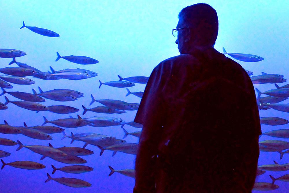
Mackerel school in Monterey harbor; city tech protect them from suffocation.

Mackerel

These Pacific mackerel are swimming inside a Monterey Bay Aquarium tank, unlike their wild kin now schooling in Monterey Harbor.   — Merve Girgin Yanar


Steve Scheiblauer keeps a photo in his office of a bunch of dead sardines. As framed desktop photos go, it’s a bit macabre compared with the more standard child’s school portrait. But in its own way, Scheiblauer’s photo is feel-good, too.

It was October 1996, and Scheiblauer was less than a year into his job as Monterey harbormaster when thousands of sardine carcasses started floating up in the marina.

The walls of Fishermans Wharf, the commercial wharf and the harborfront connecting them form a three-sided enclosure, Scheiblauer explains. When fish school there, they become vulnerable because the tides don’t bring much fresh oxygen.

“This is not really unusual for harbor structures,” Scheiblauer says. “I basically knew what was happening and how to solve it, which was these aeration machines.”

Scheiblauer convinced Monterey City Council to approve a system of 15 aerators, at a cost of about $100,000, which was installed in early 1997. Since then, he says, the aerators have helped keep visiting schools of fish (mostly sardines) alive.

Nearly 20 years since that sardine die-off, Monterey Harbor is again hosting a visiting school of fish. In an unusual twist, the school is about 80-percent mackerel, Scheiblauer says, and only 20-percent sardines.

Two days ago, he had the aerators turned on.

Here’s the underwater GoPro video his employee, A.J. Young, recorded late yesterday afternoon. With the aerators blasting out fresh oxygen, it’ll hopefully be a pleasant visit for the fish.


Read the original post: Monterey County Weekly

Jun 27 2015

Holy mackerel! Monterey Harbor working to keep fish invasion from dying off

Monterey >> Beneath the still waters of the Monterey Harbor lurks a grave threat to the tranquility of the city’s picturesque waterfront.

Mackerel. Tons of them.

Oh, they may not look like much of a menace. And alive, they are no problem.

But dead, they can foul the water and air for days on end, a disaster the likes of which the harbor has not seen in 20 years. Right now, the only thing between a pleasant day at the wharf and walking around with clothespins on our noses are 15 high-powered aerators working overtime to pump enough oxygen into the water to keep the fish alive.

“They’re heavy-duty commercial machines,” said Harbormaster Steve Scheiblauer, who first noticed the invasion early this week. “In the 19 years or 18 years since we’ve put ‘em in, we’ve had at least a half a dozen very large schools of fish, mostly sardines, that have come in, and we feel they’ve kept them alive.”

Fish kills are a relatively common harbor phenomenon, occurring when enough fish swim into a harbor to use up all the oxygen. When they die, they sink. When they rise to the surface a few days later, they stink.

The long, narrow Santa Cruz Small Craft Harbor has seen fish kills with relative frequency, including last year. To clear the mess takes a bucket brigade and volunteers with exceptional olfactory tolerance levels.

But Monterey’s harbor has not seen a problem since 1995, when sardines died off and yucked up the marina. In early 1997, the city spent about $100,000 to install the aerators.

“It was absolutely horrible,” Scheiblauer said, saying about 400 to 500 tons of fish were sent to a landfill.

On Wednesday night, part-time harbor employee A.J. Young dropped a camera into the water to see if he could find the fish. The video shows legions of them, packed gill to gill. A few sardines have also joined the mob.

Recent slack tides haven’t helped, but those are expected to change in the coming days. Scheiblauer said normal tides could signal the end of the siege.

“The tides will improve into more spring tides, real highs and real lows, and so that’ll help the oxygen in the water naturally,” he said.

mackerelWatch the video — MontereyHerald.com.


Read the original post: Monterey Herald

Jun 27 2015

NOAA Finds West Coast’s Massive Domoic Acid Bloom is Among Most Toxic Ever Recorded

— Posted with permission of SEAFOODNEWS.COM. Please do not republish without their permission. —

Seafood NewsSEAFOODNEWS.COM [Phys Org] by Hannah Hickey and Michelle Ma – June 26, 2015

The bloom that began earlier this year and shut down several shellfish fisheries along the West Coast has grown into the largest and most severe in at least a decade.

UW research analyst Anthony Odell left June 15 from Newport, Oregon, aboard the National Oceanic and Atmospheric Administration’s research vessel Bell M. Shimada. He is part of a NOAA-led team of harmful algae experts who are surveying the extent of the patch and searching for “hot spots”—swirling eddies where previous research from the UW and NOAA shows the algae can grow and become toxic to marine animals and humans.

“The current bloom of Pseudo-nitzschia spp., the diatom responsible for domoic acid and amnesic shellfish poisoning, appears to be the biggest spatially we have ever observed,” Odell said. “It has also lasted for an incredibly long time—months, instead of the usual week or two.”

Odell is the coastal sampling coordinator at the UW’s Olympic Natural Resources Center in Forks, Washington, part of the UW College of the Environment. From his base in Hoquiam, Odell samples shellfish, phytoplankton and water quality, and responds to toxic algae bloom events along Washington’s outer coast.

Now he is doing toxin sampling on the three-week first leg of the NOAA voyage, from San Diego to San Francisco. Three more legs will continue through mid-September, surveying up to the north end of Vancouver Island.

The first samples collected from near San Diego were fairly clean, Odell said, suggesting they were still south of the patch. More recent samples collected this week from near Santa Barbara showed the first signs of the harmful algae. The massive bloom is known to extend at least from central California to Vancouver Island, with reports coming from as far north as Alaska.

As the ship travels north it is making a large back-and-forth grid, sampling the water from very near shore to several miles offshore. NOAA scientists initially scheduled the cruise to survey sardine and hake. Researchers from the UW, NOAA and other partners were invited to join and use the opportunity to conduct a large-scale sampling for marine toxins.

The bloom includes some of the highest toxin levels ever recorded in Monterey Bay, California, and along the central Oregon coast. All of Washington’s razor clamming beaches are currently closed, and the southern coast of Washington has the largest-ever closure of our state’s Dungeness crab fishery.

For the past 12 years, Odell has been a research analyst for the UW-led Olympic Region Harmful Algal Bloom Partnership. The organization provides monitoring data and other information about toxic algae blooms to coastal communities on Washington’s Olympic Peninsula.

The UW’s Washington Sea Grant is involved in a similar monitoring effort for Puget Sound, SoundToxins, which has some 50 volunteers monitor 33 sites weekly throughout the sound.

The massive bloom that emerged this spring comes after a few relatively quiet years. While the phenomenon is natural and cannot be prevented, better knowledge could help to predict and prepare for its effects.

In recent years, UW oceanographers including Barbara Hickey and Ryan McCabe sampled coastal waters to help identify the origin of toxic Pseudo-nitzschia cells on the Washington and Oregon coasts. The studies resulted in the development of computer models that can simulate how the blooms travel.

Researchers pinpoint massive harmful algal bloom

Computer-based forecasts rely on continuous observations from onshore sampling efforts and offshore buoys. A regional ocean-observing data portal led by Jan Newton, an oceanographer at the UW Applied Physics Laboratory, combines water observations from federal, state and other agencies and provides that information and some forecasts to users in real time.

“Such observations are critical to understanding what new elements in the coastal ocean produced such a massive toxic bloom this year, and whether we should expect these conditions to continue,” Hickey said.

The main culprit for the current toxicity is Pseudo-nitzschia, a tiny algae that under certain conditions releases an acid that acts as a neurotoxin. On campus, UW oceanographers are using genetic tools to better understand these microscopic creatures and learn how they respond to changing conditions.

What caused the current bloom remains a mystery. Nick Bond, a research meteorologist at the UW Joint Institute for the Study of the Atmosphere and Ocean, coined the term “the blob” for the current huge patch of unusually warm water off the West Coast, and has studied its origins. Whether warm water is connected to the algal bloom is unknown.

“Our goal is to try to put this story together once we have data from the cruises,” Vera Trainer, a NOAA scientist and UW affiliate professor of aquatic and fisheries sciences, told the Seattle Times. She manages the Harmful Algal Blooms Program at NOAA’s Northwest Fisheries Science Center and is overseeing the current sampling effort.


Subscribe to seafoodnews.com